
September 14, 2025
This research experiment is led by Dr. Glenn Healey at the University of California, Irvine, in collaboration with University of California San Diego’s ALERTCalifornia and the UCSD High Performance Wireless Research and Education Network (HPWREN).
The goal is to demonstrate how co-located hyperspectral and thermal multispectral sensors – integrated with existing camera and meteorological assets – deliver near real time information on air quality, vegetation and soil condition, and earliest possible fire cues for San Diego County communities.
Why Birch Hill, Palomar Mountain (San Diego County)
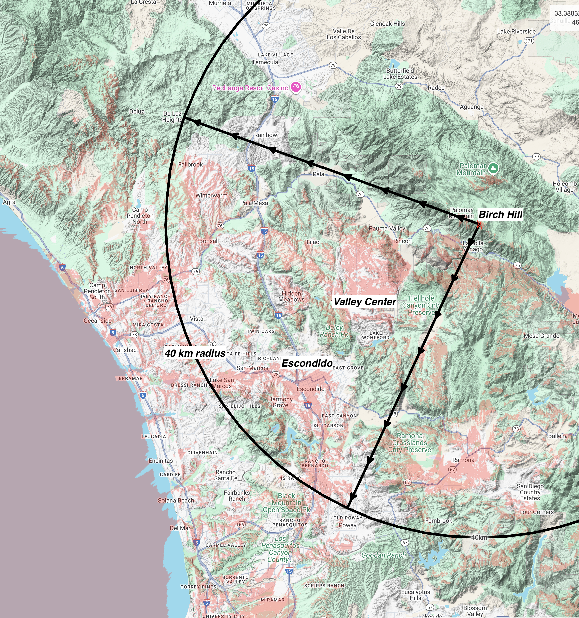
Figure 1: Birch Hill viewshed map. Terrain view, red shading are locations with line-of-sight to Birch Hill. The range ring is a 40 km radius from Birch Hill. The view from the multispectral and hyperspectral sensors is between the two arrowed lines.
Birch Hill provides a commanding viewshed for early warning and land monitoring. From the summit, the instruments overlook portions of the Federal Responsibility Lands, State Responsibility Lands, and Tribal lands as well as the communities Valley Center, Ramona, Pauma Valley, the San Luis Rey River corridor, and ridge systems toward Pine Mountain and Rodriguez Mountain. The site’s elevation provides clear-air sightlines that routinely extend to ~40 km, enabling horizontal gas and aerosol retrievals over multiple communities while keeping persistent eyes on high-risk fuel beds (see Fig. 1).
Relief, slope, and aspect across the Palomar–San Luis Rey gradient create sharp hydro-climatic contrasts. North- and east-facing slopes retain moisture and support denser woody canopies; south- and west-facing slopes dry quickly and favor flammable shrublands. These contrasts, together with soil variation, produce strong, measurable signals in spectral water absorption, canopy chemistry, and thermal behavior—ideal for testing and validating multi-sensor products.
Expected vegetation patterns along the viewshed
- San Luis Rey River canyon and Pauma Valley (lower elevations): Riparian woodland/scrub along the river; adjacent agriculture and patches of coast live oak; surrounding foothills with coastal sage scrub and chaparral transition.
- Valley Center uplands: Mosaic of coastal sage scrub, mixed chaparral (chamise, manzanita, ceanothus, scrub oak), and pockets of coast live oak/Engelmann oak on suitable soils.
- Mid-elevation slopes toward Pine Mountain and Rodriguez Mountain: Extensive chaparral on sun-exposed slopes, with oak woodlands in cooler/aspect-sheltered positions.
- High elevations near Birch Hill: Mixed conifer–oak forests and small montane meadows—valuable for monitoring moisture stress, heat risk in forests, and post-drought recovery.
Operational connectivity and HPWREN
Birch Hill is an SDG&E communications site with reliable power and high-bandwidth HPWREN connectivity (≈1.7 Gbit/s aggregate, multiple links), enabling continuous streaming of hyperspectral/thermal data and resilient operations during red-flag events.
Co-located observational assets (ALERTCalifornia or HPWREN) include:
- Four HPWREN fixed-field-of-view cameras (each at least 90° aperture) providing quadrant coverage for continuous situational awareness.
- Two ALERTCalifornia PTZ cameras for targeted interrogation, zoom, and operator-directed confirmation.
- HPWREN Meteorological sensors (e.g., wind, temperature, humidity, pressure) for context, dispersion, and model fusion.
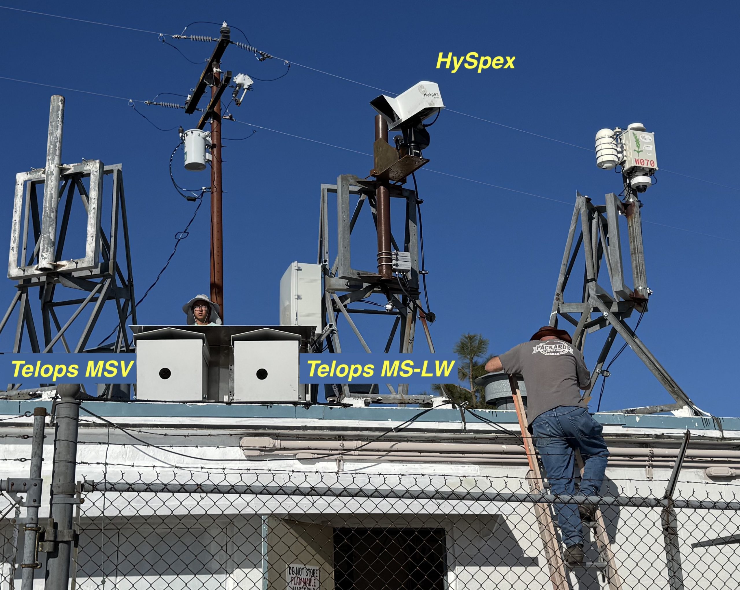
Figure 2: Installed instrument stack at Birch Hill. HySpex Mjolnir VS-620 hyperspectral and Telops multispectral thermal cameras — MSV-1k (MWIR) and MS-LW (LWIR) — mounted on stabilized pan/tilt. Note sunshade, calibration panel/blackbody references, HPWREN backhaul hardware, and weather mast. Include inset showing approximate scan-azimuth coverage.
These assets, combined with the hyperspectral and thermal instruments (Fig. 2), support rapid cross-validation (spectral cue ↔ visual/thermal confirmation) and higher-confidence alerts.
What these sensors do
Instruments at Birch Hill
-
Figure 3: Example data from Birch Hill. Upper panel is a color image generated using three bands of a Birch Hill Hyperspectral SWIR image and the lower panel is a color image generated using three bands of a Birch Hill Hyperspectral VNIR image.
HySpex Mjolnir VS-620 (NEO, Norway) — a VNIR–SWIR hyperspectral imager covering 0.4–2.5 µm with hundreds of contiguous, narrow bands. Strengths: physics-based retrievals of vegetation and canopy traits (e.g., chlorophylls, nitrogen, leaf mass per area), proxies of live fuel moisture via water-absorption features (~970, 1200, 1450, 1940 nm), surface/soil properties (texture, organic matter, salinity, mineralogy), and aerosol/smoke column characterization. Ideal for early stress detection, fuel-condition mapping, and land-surface classification across complex terrain. Example data are shown in Fig. 3.
- Telops MSV-1k (MWIR, ~3–5 µm) — a fast multispectral thermal camera with user-selectable bands and high frame rates. Strengths: earliest flame detection, sub-pixel fire temperature and area estimation, and fire radiative power (FRP), operating day/night and through moderate smoke.]
- Telops MS-LW (LWIR, ~7.5–11.5 µm) — a multispectral long-wave thermal camera. Strengths: detection of smoldering and low-temperature hotspots, heat-anomaly mapping, perimeter and residual-heat monitoring, and nighttime situational awareness.
- Hyperspectral imagers measure hundreds of narrow, contiguous wavelengths across the visible to short-wave infrared (≈0.4–2.5 µm). Thermal multispectral cameras observe targeted bands in the mid- and long-wave infrared (≈3–12 µm). Together, they convert reflected and emitted light into quantitative indicators of gases and aerosols in the air, plant chemistry and function, surface and soil water content, and sub-pixel heat from nascent fires. These measurements complement satellites (broad coverage) and in-situ monitors (high accuracy, limited footprint) by providing continuous, community-scale insight.
Air quality and exposure
Differential optical absorption spectroscopy techniques translate spectral absorption and scattering into actionable air-quality products. From Birch Hill’s elevation, horizontal sensitivity typically extends several kilometers to several tens of kilometers; under clear conditions we design for line-of-sight coverage to ~40 km across the San Luis Rey – Pauma – Valley Center corridors (see Fig. 1).
Two complementary products drive decisions:
- Gases (e.g., NO₂, HCHO): Multi-axis viewing of UV–VIS absorption supports urban-scale plume mapping and trend analysis. Sensitivity and spatial reach depend on visibility and scattering, with several tens of kilometers feasible under favorable conditions.
Particles (PM₂.₅): Spectral extinction (AOD) fused with meteorology and priors yields surface PM₂.₅ at near real time; physics-based approaches used regionally can be adapted to community scales from a fixed mount.
Climate accountability (methane)
Imaging spectroscopy is enabling source-level accountability. Airborne and, increasingly, spaceborne sensors identify and quantify methane plumes from individual facilities, supporting targeted mitigation and verification. Ground-based deployments extend this capability with near real time and persistent coverage in complex terrain.
Forest and ecosystem condition
Vegetation chemistry and function leave rich spectral fingerprints. Hyperspectral data retrieve canopy traits—chlorophylls, nitrogen, and leaf mass per area—and related physiological metrics linked to stress and productivity. These traits shift early under drought, disease, or disturbance, providing an early-warning lens that precedes visible decline and guides interventions.
Fuel moisture and fire potential
Live fuel moisture (LFMC)—a primary control on ignition and spread—modulates NIR–SWIR reflectance via water-absorption features. Using spectral indices, radiative-transfer approaches, and modern ML, we will estimate LFMC at operational scales-as part of a comparative analysis against established industry-standard monitoring practices, ensuring traceability to current decision frameworks. In parallel, thermal multispectral imaging enables sub-pixel fire characterization (temperature, area, radiative power) for rapid, day/night detection and intensity estimation—even through moderate smoke.
Soil moisture and land surface properties
Optical/SWIR spectroscopy diagnoses near-surface moisture and key soil attributes (texture, organic matter, salinity, mineralogy) via well-understood absorption features and mixture behavior. These maps explain why water is—or is not—available to plants, help anticipate dust risk, and inform post-fire recovery and erosion control.
From spectra to decisions: what stakeholders receive
- Near-real-time fire intelligence: Thermal sub-pixel detection and fire radiative power measurements aid rapid confirmation and growth characterization, day or night.
- Neighborhood-scale air-quality diagnostics: NO₂ plume mapping for source attribution; PM₂.₅ estimates linked to composition and transport to explain local conditions.
- Fuel and vegetation condition: Weekly fuel-moisture indicators and canopy-trait stress alerts to prioritize treatments, staffing, and patrol routes under forecast winds.
- Soil and surface moisture: Fine-scale surface-moisture and soil-property maps to inform dust control, trail/road closures, and post-fire erosion mitigation.
Why now
The science is mature and operational pathways are proven: hyperspectral trait mapping for forest stress, LFMC mapping for fire danger, optical soil-moisture retrievals for land management, and source-level methane detection for climate accountability have moved from research to practice. By co-locating these sensors with robust backhaul at Birch Hill, we bring those capabilities to a continuous, community scale—so managers can detect earlier, explain conditions better, and act faster.
– Frank Vernon (HPWREN/SIO/UC San Diego), Glenn Healey (Calit2/UC Irvine) and Hans-Werner Braun (HPWREN/SDSC/UC San Diego)