
September 15, 2025
Pioneering work by the University of California San Diego’s HPWREN program on the deployment of optical cameras and wireless communications hardware on mountain tops has led to a network of more than seven hundred ALERTCalifornia stations throughout the state. Early in the spring of 2025, hyperspectral and multispectral image sensors were installed at the backbone site at Birch Hill on Palomar Mountain in a collaboration involving HPWREN, Calit2, and ALERTCalifornia. The new sensors acquire spectral imagery 24/7 over the visible (V), near-infrared (NIR), short-wave infrared (SWIR), mid-wave infrared (MWIR), and long-wave infrared (LWIR) and transmit the data to Calit2 at UC Irvine over a 1.4 gigabit per second wireless link. These sensors provide an unprecedented ability to capture the spectral/spatial/temporal structure of the environment and are particularly useful for the early detection of wildfires and characterizing the pre-fire, active fire, and post-fire environment. The spectral sensors are also being used for the continuous assessment of air quality and chemistry over the region.
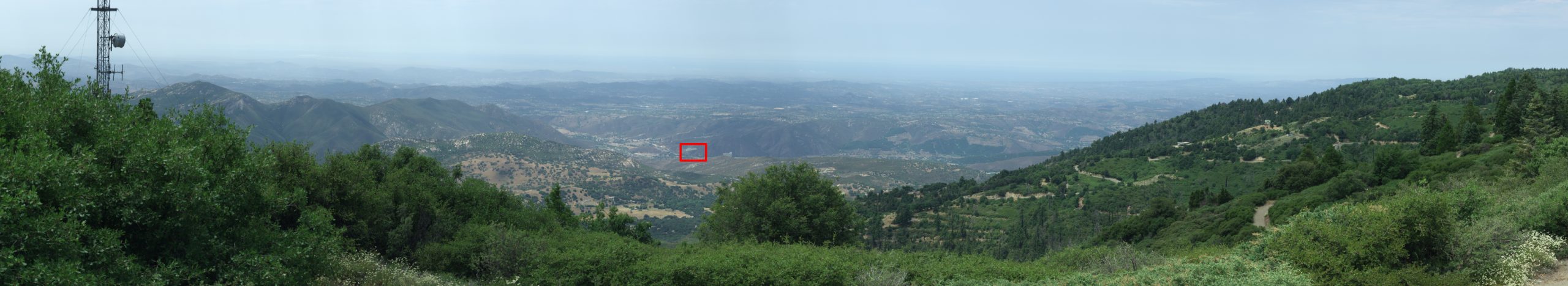
Figure 1. HySpex data captured on 17 July 2025 at 12:23pm
The image sensors include the HySpex VS-620 hyperspectral imager that acquires 500 narrow contiguous wavelength bands at each pixel over the VNIR/SWIR (0.4 – 2.5 microns), the Telops MS-M100hd imager that generates eight bands over the MWIR (3.0 – 5.0 microns), and the Telops MS-V1k imager that generates eight bands over the LWIR (7.5 – 11.5 microns). The HySpex sensor is equipped with pan/tilt hardware and scans a 105 degree horizontal Field of View (FoV) as shown in Figure 1 to generate 6788 x 1240 hyperspectral pixels every two minutes. The real-time data can be viewed and downloaded at hyspex-birchhill.com. The MWIR and LWIR sensors each provide up to 800 frames per second. The MWIR sensor generates 1280 x 1024 pixels over a (42° H/34.2° V) FoV and the LWIR instrument generates 640 x 512 pixels over a (35.5° H/28.7° V) FoV. The sensors have been optimized for the measurement of emissions from the most significant species associated with wildfires including methane (CH4), ethane (C2H6), carbon monoxide (CO), carbon dioxide (CO2), water vapor (H2O), potassium (K), sodium (Na), ammonia (NH3), nitric oxide (NO), nitrogen dioxide (NO2), nitrous oxide (N2O), ozone (O3), and sulfur dioxide (SO2).
During the pre-fire phase, spectral imagery is used for risk assessment by the continuous pixel-by-pixel labeling of fuel type and condition over the field of view of the sensors. Vegetation, in particular, can be classified according to species type, moisture, and chlorophyll content which affect combustion properties. In southern California, fuel moisture is currently assessed by the monthly collection and analysis of a few grams of leaves at a small number of locations and by assuming that these samples are representative of vegetation health over hundreds of square miles. During the post-fire phase, spectral imagery can be used to evaluate fire severity and to track vegetation recovery over time.
A physics-based fire detection algorithm has been developed at Calit2 UCI and was first demonstrated using the HySpex sensor on data collected during the daytime from prescribed burns less than a mile from the sensor at Sedgwick Reserve in southern California. This algorithm successfully detected all fires without false alarms in these tests. Similar results were obtained after the HySpex sensor was installed at Birch Hill for a real brush fire in Valley Center about 10.7 miles from the sensor on August 4, 2025. Since smoke penetration increases at longer wavelengths, the spectral sensors allow for the boundaries of a fire to be accurately localized and tracked through smoke. Compared to other approaches, the spectral sensors allow for earlier fire detection and higher resolution fire, temperature, and species emission maps.
On the evening of April 29, 2025, a small fire detection experiment was conducted to evaluate the spectral sensors at Birch Hill. The experiment was arranged by Hans-Werner Braun from UC San Diego/HPWREN. Critical for the success of the experiment was the participation of staff from the Southern California Tribal Chairmen’s Association (SCTCA) Tribal Digital Village Network (TDVnet), in particular Joseph Peralta, Paul Miranda, Pouya Bahari and Matthew Rantanen, as potential fire test locations were collectively chosen to be on tribal land of the Rincon Band of Luiseño Indians. Joseph Peralta coordinated with the Rincon Fire Chief who provided the project with his training rig and a fire crew to guarantee the safety of the experiment.
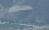
Figure 2. Zoomed-in location of the Rincon test fire
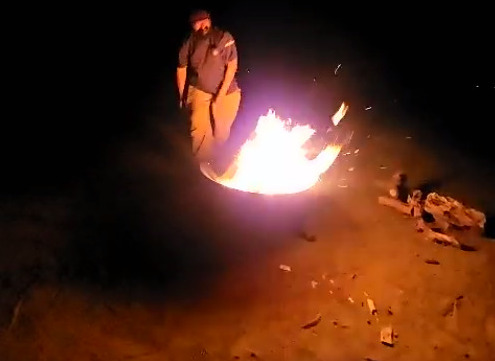
Figure 3. Test fire on the evening of 29 April 2025
The distance between the Birch Hill sensors and the Rincon fire test was about 6.8 miles. The general location of the fire in the HySpex FoV is indicated by the red box in Figure 1 and the fire itself was located at the center pixel of the 101 x 63 pixel region shown in Figure 2 which corresponds to the red box. At this distance, the area of a HySpex pixel in a plane perpendicular to the line of sight is about 94 square feet and the fire used for the experiment had an estimated projected area of less than 5 square feet. The fire is shown in Figure 3 and was fueled by wood inside a fire pit with a diameter of 30 inches. Despite the fire occupying less than ten percent of a pixel, it was easily detected shortly after ignition at 8:42pm without false alarms over the FoV of the sensor.
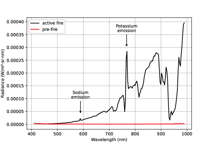
Figure 4. VNIR spectrum for fire pixel before and after ignition
The black curve in Figure 4 is the HySpex VNIR spectrum at a pixel where the fire was detected and the red curve is the corresponding spectrum for the same location before the fire started. We see a strong potassium emission feature between 766nm and 770nm and a sodium emission feature near 589nm. For the same time and location, the LWIR sensor with a projected pixel area of 1194 square feet detected a pixel temperature increase between about 290K and 292.5K as shown in Figure 5 which gives a fire temperature estimate of 1140F.
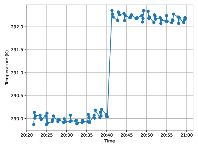
Figure 5. LWIR fire pixel apparent temperature increase as ignition occurs
The hyperspectral sensor enables the fast reliable detection of fires that cannot be detected using conventional cameras. For example, the test fire was also visible as a bright spot in the images obtained by the standard fixed field of view HPWREN cameras (Mobotix M16) soon after ignition as shown in Figure 6. These cameras capture 3072 x 2048 pixels over a 90 degree FoV which is approximately a factor of two worse in each dimension than the spatial resolution for the HySpex hyperspectral sensor. Although the fire appears as a bright spot in the images obtained by the HPWREN cameras, it cannot be distinguished from non-fire sources with similar color and brightness.
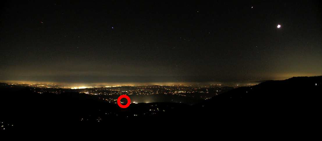
Figure 6. Rincon fire as viewed by the HPWREN Mobotix M16 camera
The VNIR/SWIR hyperspectral measurements depend on properties of the atmosphere in the sensor’s field of view and provide the opportunity to generate continuous wide-area atmospheric descriptions that include PM2.5 at high spatial resolution. This sensor data can also be used to recover the concentration of the most significant components of PM2.5 such as sulfate, dust, and brown carbon. These spectra have significant spectral differences which enables machine learning algorithms to recover the concentrations of these aerosol types from images over a broad range of unknown conditions.
The success of this project has been the result of contributions from many people and collaborating organizations, too numerous to all include here. However, as for direct participants in this experiment, the authors are explicitly extending their thanks to Joseph Peralta, Paul Miranda, Pouya Bahari, and Matthew Rantanen from SCTCA/TDVnet, the Rincon Fire Department via their Chief and crew who assured safety, UCI students and staff Weishi Li, Wuhao Ben Jiao, Adrian Nguyen, and Rongwei Mao, SDG&E for hosting the instruments at their Birch Hill site, and University of California San Diego’s ALERTCalifornia program for securing funding for the hyperspectral equipment.
– Glenn Healey (Calit2/UC Irvine) and Hans-Werner Braun (HPWREN/SDSC/UC San Diego)