One of the dominant challenges for California’s future will be its changing climate, the result of human-induced alterations of natural landscapes and global climate disruption. The Scripps Institution of Oceanography has prepared 50-year forecasts for regional climate change throughout California. From these studies, it appears that there will be severe disruptions to water availability, growing threats from wildfires, and increased erosion, flooding and pollution of coastal regions. CALIT2 believes the digital transformation of monitoring and modeling the environment can provide solutions to these challenges.

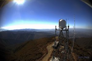 When a wildfire started in Orange County California’s Holy Jim Canyon last summer, a new ally
 Environmental research, particularly in all areas related to water, is a major focus of UCI expertise. A few years ago, several leaders conducting water-related research found a new home in CALIT2. Brett Sanders, professor of civil and environmental engineering, is the principal investigator on several projects: the NSF-funded FloodRISE, the NOAA-funded SedRISE and the Blum Center for Policy Alleviation Flood Risk Initiative. Sanders moved his research team into CALIT2’s third floor, citing close alignment with CALIT2’s mission. The team’s highly interdisciplinary work brings together researchers from engineering and social ecology to leverage the power of information technology and behavioral sciences to advance the field of flood risk and disaster management. The researchers use advanced information technologies, namely flood simulation and visualization technology, and proven social science tools, such as surveys, focus groups and stakeholder meetings, to craft flood risk and environmental information that meets end-user needs for decision-making.
CALIT2
California Institute for Telecommunications and Information Technology
4100 CALIT2 Building
University of California, Irvine
Irvine, CA 92697
949-824-6900


California Institute for Telecommunications and Information Technology
4100 CALIT2 Building
University of California, Irvine
Irvine, CA 92697
949-824-6900
© CALIT2, University of California, Irvine 2025